Photo mapping
How to Make a Travel Map from Your iPhone Photos
Your photo library may already contain the dates and coordinates needed to reconstruct years of travel. Here is how to check the data, build the map, and keep the result useful and private.
What your iPhone photos already know
An iPhone photo can carry two pieces of travel history that matter most: when it was taken and where it was taken. With enough located photos, those points can be grouped into countries, regions, and cities, then arranged into a dated record.
This is different from continuous GPS tracking. A photo-based map reconstructs the places represented in your library without needing an always-running route recorder. It will not recover a place that has no located photo or other source record, so the finished map should remain editable.
First, check whether your photos have location data
Check a small sample from different years and devices before scanning the entire library. Recent iPhone photos often contain coordinates when Location Services was available to Camera, but screenshots, downloaded images, scans, and photos received from other people may not.
- Open a travel photo. Choose a picture you took on a trip in the Photos app.
- Show its information. Swipe up on the photo or tap the Info button.
- Look for a map. A map or address confirms that the photo includes a usable location. Repeat this with a few trips from different years.
Worth knowing: If a photo has no location, a travel-map app should not silently guess where it was taken. You can add or correct locations in Photos, or add the missing place manually in Mapsake.
Build the first version of the map
Mapsake is designed to make this first pass reviewable. It reads supported dates and coordinates, matches them to its on-device place data, and shows what it found before the atlas changes.
- Open Record. From the Atlas, open Record, where manual additions and imports live.
- Choose Add locations from Photos. Grant access to the photos you want to use. You can change the Photos permission later in system settings.
- Let the scan finish. Mapsake groups located photos and resolves their countries, regions, and cities on the device.
- Review before saving. Inspect the discovered timeline and remove anything that does not belong before confirming the import.
Treat the first result as evidence, not a verdict
Photo metadata can describe where a camera was, but it cannot always explain why. Airport connections, photos taken from a plane, old scanned pictures, and images saved from other people can all create misleading points. A trustworthy atlas needs a review step and lasting editing controls.
Mapsake lets you exclude specific places and filter photo evidence by device, altitude, speed, minimum photo counts, screenshots, and edited media. Missing destinations can be added manually, while an incorrect date or note can be changed without rebuilding the entire map.
- Remove a connection airport if you do not count it as a visit.
- Raise the minimum photo count when isolated images create noise.
- Disable a camera or source that contributed imported or scanned images.
- Add places manually when the trip was real but no located photo survived.
Turn the map into something you will actually revisit
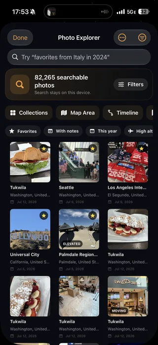
A country count is a useful start, but the dates and photos are what make the atlas personal. In Mapsake, each destination can become a place story with its photos, days on the ground, regions, cities, and notes. Photo Explorer adds search, collections, a map, and a timeline across the whole library.
The same history can drive heatmaps for photo count, recency, and time spent; On This Day memories; Passport cards; and a yearly Mapsake Rewind. The goal is one durable record that becomes more valuable as the library grows.
Do a privacy check before choosing any photo-map workflow
Photo locations can reveal homes, routines, and exact moments. Before granting access, check whether the app uploads the library, requires an account, sells behavioral data, or publishes anything automatically.
Mapsake performs its supported photo matching and place resolution on the device. The core app does not require a Mapsake account, and sharing is a separate action you control. That design keeps the private source library distinct from the cards, reels, or read-only maps you intentionally publish.