A private travel tracker built from what you already have
Your travels, your memories, one living atlas.
Mapsake builds a travel map from your Photos on your device, then lets you shape it into the places you've visited, lived, and want to go next. No blank checklist, account, ads, or subscription.
 Free on the App Store
Start with what you have
Build it once. Keep discovering it.
Begin with your photo library or an existing travel history, then use the same private atlas to explore, remember, and share a lifetime of places.
Start with your history
Turn Photos into places on device, or preview an import from another travel tracker.
Try the free photo map maker → 02 · ExploreFind any travel photo
Search by place, year, camera, note, favorite, or everyday language without uploading anything.
03 · RememberRelive the journey
Return through place stories, memories, Constellations, and a private travel year in review.
04 · ShareMake it worth showing
Create Passport cards, spinning-globe reels, and optional read-only maps for friends.
Already have a map? Browse the supported import guides →
The idea
Three lenses. One atlas.
Every place you add lives under one of three enduring states. Switch a lens to recolor your whole world, or see all three at once in the combined view.
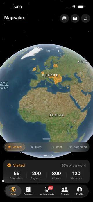
visited
Everywhere you've set foot: countries, states and provinces, cities, and airports. Your travel completion, beautifully tracked.
lived
The places that were home. The chapters of your life, mapped with dates and notes.
next
The trips still ahead. A calm wishlist that turns into memories as you go.
Build your travel bucket list →The atlas
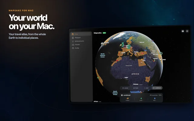
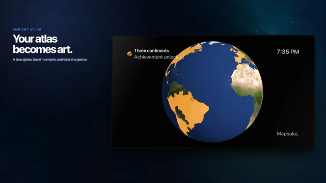
A globe that feels like a keepsake.
The live globe is Apple Maps: a real satellite Earth with the stars behind it when you zoom out, streaming streets, terrain, and points of interest as you zoom in, with your countries painted on top. Tap any country or region to open its story.
- Zoom out for the globe, in for streets and terrain, with a Reset to bring it home
- Label with country names or flags, float waving state flags as you zoom, or turn labels off
- Marked countries show as a translucent fill or a glowing outline, states colored individually
- Pin where you live, and see friends' homes on your map too
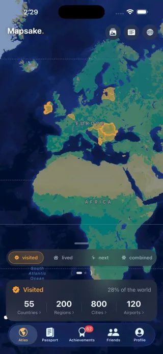
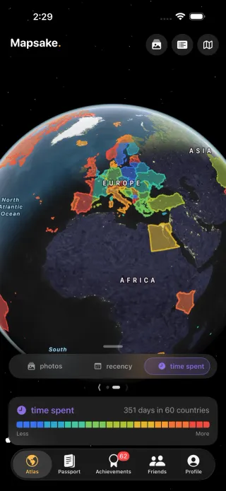
Color by data
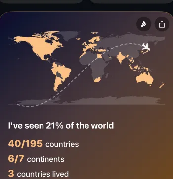
See your travels in color.
Swipe the lens picker to a second set of views and your countries become a heatmap, shaded by how many photos you took, how recently you visited, or how long you stayed. Each view has its own legend, and you can share the same map from your Passport.
- Photos, recency, and time-spent views over your whole map
- Log or linear shading, with a clear legend on every view
- A colorful, shareable data map in your Passport
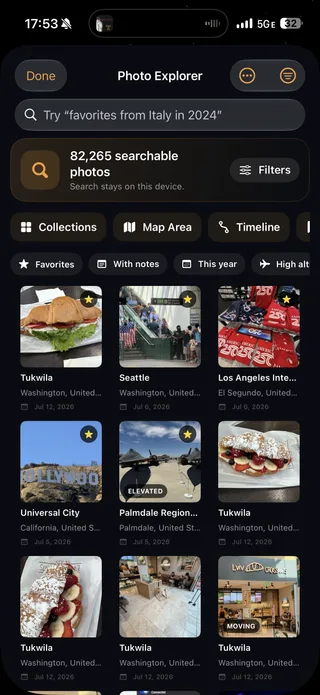
Photos on the map
Pins where you took your photos.
Zoom in and a pin appears at every spot you took a photo. Tap one to flip through those shots in a full-screen viewer, complete with each photo's date, camera, location, altitude, and speed, then share or copy it.
Every photo is matched to a place entirely offline. Nothing ever leaves your device.
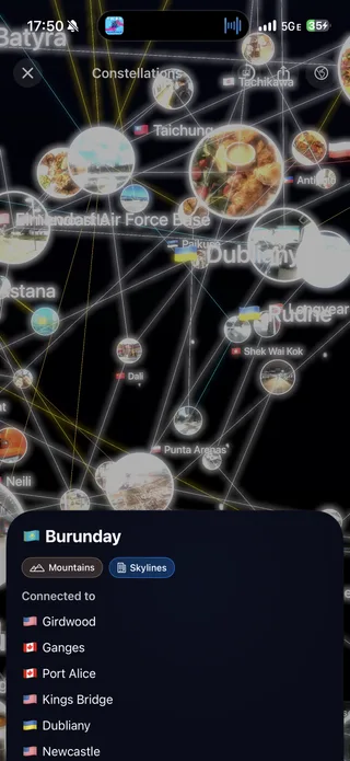
New: Constellations
Your memories, connected.
Mapsake privately studies the photos on your map and discovers connections between distant places: the doorways, coastlines, light, and seasons you keep returning to. Chart your sky, watch each constellation form live, then explore the night sky your travels leave behind.
- Match-cut cinema: tap Play and photos dissolve one place into the next, full screen
- Threads to keep or dismiss, a sky you can wander, and a card for your Passport
- Every photo is analyzed on your device. Nothing is ever uploaded.
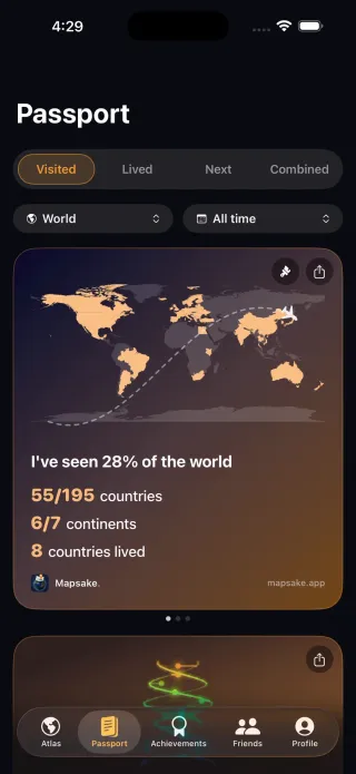
Passport
Share-ready stats, in a tap.
Colorful, swipeable passport cards capture your percent of the world, continents, flags, time spent, and per-lens breakdowns. Each one renders to a beautiful image you can share instantly, and recolor to your taste.
- A live spinning-globe card you can share as a looping reel video
- Body Clock: the jet-lag ledger of your life, in three cards
- Scan your real passport stamps into collectible books and a stamp wall
- Rewind: a year-in-review reel, plus filters by region or year
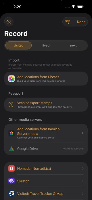
Import
Get to a full map, fast.
Bring your history in from the tools you already use, then keep it current automatically with optional background sync that quietly grows your map as you travel.
Plus Skratch, FlightRadar24, the Visited app, and easy export to JSON, CSV, Excel, or HTML, with backup and restore. It's your data. Photos are matched to places entirely offline, and it's built for big libraries: even an 80,000-photo map rebuilds in seconds.


Friends
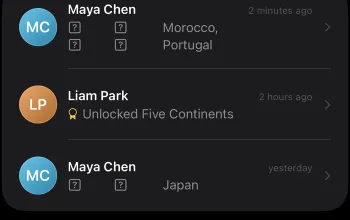
Follow each other's travels.
The Friends tab is a feed of the new places your friends add and the achievements they unlock. Add a friend with a private invite link, a QR code, or someone nearby, and their map opens fully interactive, rendered just like your own.
- Mutual and private, you choose which lenses they can see
- Compare head to head and see who leads each continent
- Turn on home sharing for a pin where each of you lives
- Publish a read-only web map anyone can open in a browser, and unpublish anytime

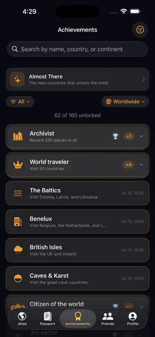
Achievements
Around 160 to chase.
Continents, country groups like the G7, NATO, and the EU, nature and economics themes, and travel milestones with bronze to platinum tiers. Tap any one for the full story and a map of where it spans, with the countries you're still missing glowing.
Each is stamped with the date you earned it, and celebrates the journey, never a streak.
Everywhere
Your world, on every screen.
One atlas, synced over your private iCloud across all your devices, with an adaptive layout on each.
Make it yours
Built to fit how you travel.
Your look
Light, Dark, and System themes, alternate app icons, and lens colors that recolor the whole app.
Your language
English, French, German, Japanese, Portuguese, Russian, and Spanish, chosen right in iOS Settings.
Lives where you do
Siri and Shortcuts, Spotlight search, an iMessage app, and a public web link for sharing your map with anyone.
Count it your way
Choose how countries are counted, and how ones that span two continents are handled.
Works offline
Search countries, regions, cities, and airports instantly, even with no signal. It's all built in.
Yours to keep
Export, back up, restore, and delete everything in one clear action. Never held hostage.
Travel DNA
Six trait axes resolve your marked world into a travel archetype, with the evidence to back it up and a helix card to share.
Fast at any scale
Built and benchmarked against libraries of 80,000+ photos. Every release is held to a measured performance baseline.
Mapsake Journal
Practical field notes for your travel data.
Guides and behind-the-scenes lessons about photo locations, privacy, mapping, and building a travel record that lasts.
Visit the Journal →Latest · Photo mapping
How to Make a Travel Map from Your iPhone Photos
Check the location data, build a reviewable first map, clean up misleading points, and turn the result into something worth revisiting.
Read the guide →
A promise, not a paywall.
Mapsake is not monetized. No ads, no in-app purchases, no subscriptions, and your data is never sold. Your places stay on your device, a durable, private record built to last a lifetime, and to leave with you whenever you want.
Read the privacy policy